Porto Santo
You can be here in October for about €704, 3 days, 1 stop.
Why now
Prime time in October: 23°C days, sea 24°C, fares below average.
High summer is when Madeirans and mainland Portuguese arrive and the beach hotels fill; late spring and early autumn have the same sand with room on it, and the sea stays warm into October. In the depth of winter many restaurants shut and the Funchal ferry stops for its annual maintenance, so check sailings before relying on it.
Best months here: September, October, November. Daytime highs, sea temperature and rainy days from three years of Open-Meteo reanalysis; a rainy day is one with at least 1 mm of rain, which is the WMO threshold and not the same as "it drizzled".
The place
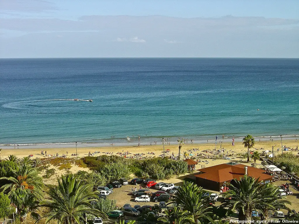
Porto Santo is Madeira's dry, flat, sandy opposite: one nine-kilometre beach of pale sand along the south coast, one small town, bare volcanic hills and not a great deal to do, which is the appeal. It suits people who want a week of swimming and walking without a resort machine; the food is plain grilled fish and the evenings end early.
What you can do
- 01Walk the full nine kilometres of beach from Vila Baleira to Ponta da Calheta, ideally on the wet sand at low tide.
- 02Hike the Pico Branco and Terra Chã trail in the north-east, a green ledge of endemic plants above the cliffs.
- 03Visit Casa Colombo in Vila Baleira, where Columbus lived after marrying the governor's daughter, then the church on the same square.
- 04Drive up to Pico do Castelo and the Portela viewpoint late in the day, windmills on the ridge and the whole island below.
- 05Eat grilled fish and lapas at the restaurants near Ponta da Calheta at sunset, looking across to the Ilhéu da Cal.
Where to stay · neighbourhoods
Stay in Vila Baleira to walk to dinner and the beach, or along Campo de Baixo for sand at the door; the resort blocks at Cabeço da Ponta are quiet and need a car or bike for everything else.
Unusual things
- ◦Pico de Ana Ferreira's old quarry face, a wall of hexagonal basalt columns locals call the organ pipes.
- ◦Fonte da Areia on the north coast, where the wind has carved yellow sandstone into ledges around a spring that is now mostly dry.
- ◦Serra de Dentro, a half-abandoned hamlet in an eroded valley on the east side, its terraces and stone houses slowly going back to the hill.
Day trips
Flight options
Routes come from OpenFlights (historical) and a 2026 route reference compiled from public timetables. Durations are the published schedule where we have it, otherwise a block-time model fitted on measured nonstop flights. Verify schedules with the airline before booking.
Entry requirements · IT passport
Source: passport-index-data, March 2026 (coarse indicator), covering 258 of our 268 destinations for each of 199 passports. Always confirm with the destination's official site.
Airports
Distances are centre to airport derived · nonstop counts are our route reference for 2026, not every flight that exists.
Local transport
- Airport to city
- Taxi, 5 min, ~€10
- Car needed?
- No — walkable or good public transport
- Getting around
- The island is eleven kilometres long: hire a bike, scooter or small car, or use taxis, as buses are sparse. The airport is five minutes from town, with short hops from Funchal and the Lobo Marinho ferry taking about two and a quarter hours from Madeira.
- Clock
- 1 hour behind Venice (Atlantic/Madeira) derived
- Daylight
- 11.4 hours of daylight in October · sunrise 08:09, sunset 19:33 derived
- Currency
- EUR
Alternatives at a similar price
Whole trip per person for 3 days from Venice in October, then the flight time; estimates, like the total above.
 Santorini
 Ibiza
Ibiza Zakynthos
 Nice
Nice Tashkent
 Tel Aviv
.jpg)