La Palma
You can be here in November for about €535, 3 days, 1 stop.
Why now
Prime time in November: 25°C days, fares below average.
The walking season is the whole year, but the trade-wind cloud sits on the east side through summer while the west stays sunny; winter brings the clearest skies at the summit and occasional snow on the road up. The Bajada de la Virgen, held every five years, fills Santa Cruz for weeks.
Best months here: September, October, November. Daytime highs, sea temperature and rainy days from three years of Open-Meteo reanalysis; a rainy day is one with at least 1 mm of rain, which is the WMO threshold and not the same as "it drizzled".
The place
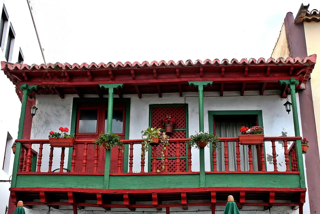
La Palma is the steepest of the Canaries, a volcanic ridge of laurel forest and banana terraces with a Caldera de Taburiente at its centre and a line of observatories on the summit. There is almost no resort development and the beaches are black and few; the island suits walkers, stargazers and people who want an old Spanish port town to sleep in.
What you can do
- 01Drive to the Roque de los Muchachos at 2,400 metres for the caldera rim and the telescopes, before the cloud rises.
- 02Walk part of the Ruta de los Volcanes along the Cumbre Vieja ridge from El Pilar refuge, over the newest cones.
- 03Walk the wooden balconies of Calle O'Daly and the Avenida Marítima in Santa Cruz, then the naval museum in the concrete ship.
- 04See the Tajogaite lava field of 2021 from the viewpoints around Tacande and Todoque, where the road is being rebuilt.
- 05Swim at Charco Azul's natural pools or Puerto Naos, and eat a papas arrugadas and goat dinner in Los Llanos.
Where to stay · neighbourhoods
Split between Santa Cruz for the town and the west side around Los Llanos or Tazacorte for the sun and the caldera; rural houses in the north suit a second week. There are no large resorts to avoid.
Unusual things
- ◦The Marcos y Cordero walk through thirteen tunnels along an old water channel in the laurel forest above Los Sauces.
- ◦Los Tilos laurel forest, a UNESCO biosphere reserve with a visitor centre and short walks on the north-east side.
- ◦La Zarza and La Zarcita, a gorge with Benahoarita rock carvings near Garafía, on a short signed path.
Day trips
Flight options
Routes come from OpenFlights (historical) and a 2026 route reference compiled from public timetables. Durations are the published schedule where we have it, otherwise a block-time model fitted on measured nonstop flights. Verify schedules with the airline before booking.
Entry requirements · IT passport
Source: passport-index-data, March 2026 (coarse indicator), covering 258 of our 268 destinations for each of 199 passports. Always confirm with the destination's official site.
Airports
Distances are centre to airport derived · nonstop counts are our route reference for 2026, not every flight that exists.
Local transport
- Airport to city
- Car essential
- Car needed?
- Recommended for most of what is worth seeing
- Getting around
- The airport is ten minutes from Santa Cruz. Buses cross the island by the tunnel but do not reach the trailheads or the summit, so hire a car on arrival; the roads are steep and winding, and the tunnel between east and west separates two different weathers.
- Clock
- 1 hour behind Florence (Atlantic/Canary) derived
- Daylight
- 10.7 hours of daylight in November · sunrise 07:34, sunset 18:18 derived
- Currency
- EUR
Good to know
The 2021 eruption zone in the Aridane valley remains partly closed and some roads are provisional; check current access and follow signs for volcanic gas areas.
Alternatives at a similar price
Whole trip per person for 3 days from Florence in November, then the flight time; estimates, like the total above.
 Casablanca
 Amman, Petra
 Crete
Crete Fuerteventura
 Tenerife
 Seville