Faroe Islands
You can be here in October for about €1,275, 4 days, direct.
Why now
Off season in October: 9°C days, 22 rainy days, fares below average.
The islands are a summer destination: puffins on Mykines, grass thick on the roofs, daylight until midnight, and a national festival that fills every room in Tórshavn at midsummer. Late spring and early autumn have fewer tour groups and the ferries still running; in winter the storms are the attraction and half the guesthouses close.
Best months here: May, September, October. Daytime highs, sea temperature and rainy days from three years of Open-Meteo reanalysis; a rainy day is one with at least 1 mm of rain, which is the WMO threshold and not the same as "it drizzled". This page stands for a whole country, and its weather is measured at one point — 62.01°, -6.77°, near Vágar. Somewhere else in Faroe Islands the numbers will differ.
The place
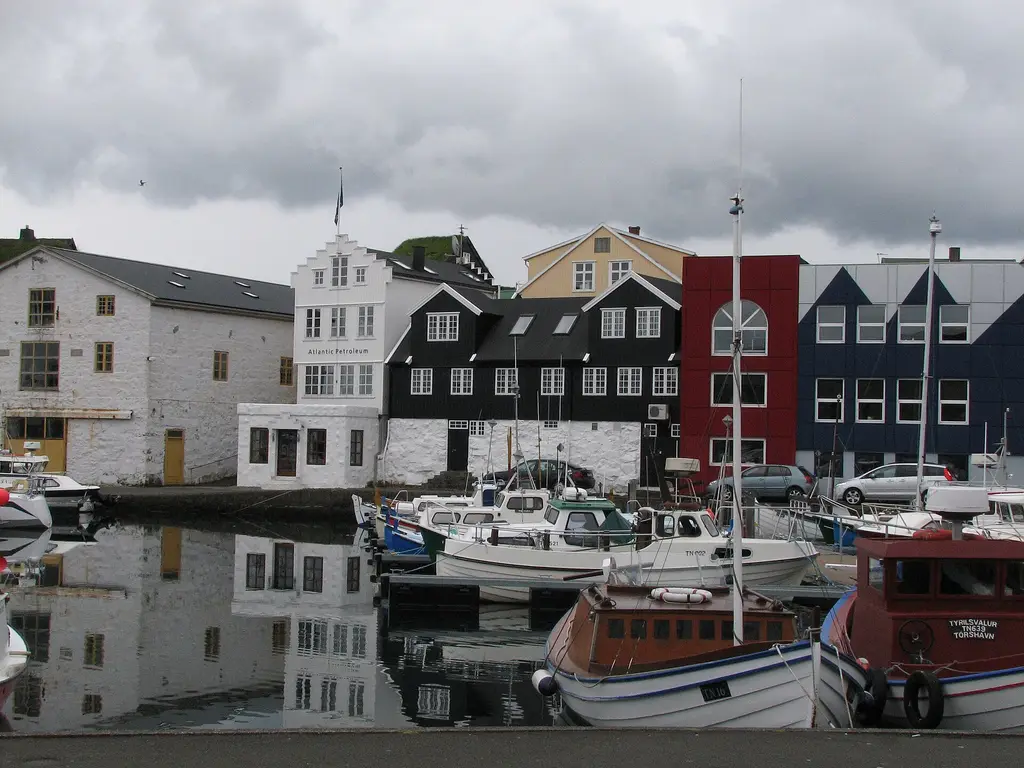
The Faroes are eighteen basalt islands where a village of forty houses sits at the far end of a road tunnel, sheep outnumber people, and dinner is wind-dried mutton unless you booked. They suit walkers and drivers who accept that the weather, not the itinerary, decides the day; anyone who needs sun, nightlife or a plan that holds should look elsewhere.
What you can do
- 01Walk Tinganes in Tórshavn, turf-roofed government houses on a rock spit where the Faroese assembly first met around the year 900.
- 02Drive to Gásadalur for Múlafossur, the waterfall that drops straight off the cliff into the sea; go early before the coaches.
- 03Hike from Miðvágur along Sørvágsvatn to Trælanípa, where the lake appears to hang above the Atlantic; there is a landowner fee.
- 04Take the boat from Vestmanna under the sea cliffs and into the grottoes, and wear the hard hat they hand out.
- 05Book heimablídni, dinner in a family's house, and try skerpikjøt and ræst fish; the fermented flavours are the point.
Where to stay · neighbourhoods
Stay in Tórshavn for a first visit; it has the restaurants, the buses and the ferries, and nothing on the road network is more than two hours away. Beds are scarce in summer, so book before the flights; village guesthouses are peaceful but you cook or drive to eat.
Unusual things
- ◦Nólsoy, twenty minutes by ferry from Tórshavn: a car-free village and a guided night walk to the world's largest storm petrel colony.
- ◦Kirkjubøur, the medieval seat of the bishops: the roofless Magnus Cathedral, St Olav's church and the Roykstovan farmhouse, lived in for centuries.
- ◦The undersea roundabout in the Eysturoy tunnel, lit in colour around a steel ring of dancing figures by Tróndur Patursson.
Day trips
Flight options
Routes come from OpenFlights (historical) and a 2026 route reference compiled from public timetables. Durations are the published schedule where we have it, otherwise a block-time model fitted on measured nonstop flights. Verify schedules with the airline before booking.
Entry requirements · IT passport
Source: passport-index-data, March 2026 (coarse indicator), covering 258 of our 268 destinations for each of 199 passports. Always confirm with the destination's official site.
Airports
Distances are centre to airport derived · nonstop counts are our route reference for 2026, not every flight that exists.
Local transport
- Airport to city
- Bus 300, 50 min, DKK 90; car essential
- Car needed?
- Recommended for most of what is worth seeing
- Getting around
- A rental car is the practical answer; undersea tunnels link Vágar, Streymoy, Eysturoy, Borðoy and Sandoy, with tolls billed to the number plate. The airport bus takes about 45 minutes to Tórshavn, the red town buses are free, blue Bygdaleiðir buses and ferries reach the rest, and the Atlantic Airways helicopter to the outer islands is subsidised and books out fast.
- Clock
- 1 hour behind Copenhagen (Atlantic/Faroe) derived
- Daylight
- 10.1 hours of daylight in October · sunrise 08:08, sunset 18:17 derived
- Currency
- DKK
Good to know
Fog and wind ground helicopters and cancel the Mykines boat without notice, cliff edges are unfenced, and sheep wander every road; build a spare day into any plan that depends on an island crossing.
Alternatives at a similar price
Whole trip per person for 4 days from Copenhagen in October, then the flight time; estimates, like the total above.
 Santorini
 Mykonos
 Shanghai
 Tel Aviv
 Washington DC
 New Orleans